
Featured 1936 HABS Photographs
A selection of HABS photographs of iconic adobe structures in El Paso County taken by architect Marvin Eickenroht in 1936 that are featured in this exhibit.
EL PASO
SIMEON HART’S MILL
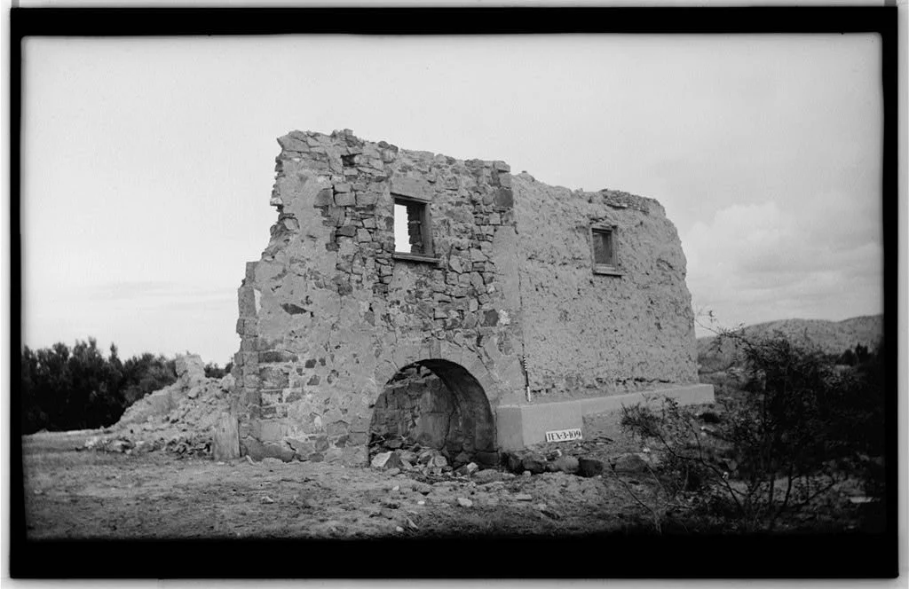
In 1849, Simeon Hart (1816–1874), a former cavalryman who fought in the Mexican-American War, married Jesusita Siqueiros (1832–1870), the daughter of a wealthy mill owner from Chihuahua. Shortly after, the couple moved to present-day El Paso, where Simeon established a grist mill on the banks of the Rio Grande along El Camino Real de Tierra Adentro. Constructed with thick stone and adobe walls, the mill was powered by water diverted from the Rio Grande.
Initially, Hart's mill supplied flour to American military outposts, but it soon expanded to serve a region stretching from West Texas to Arizona and as far north as Santa Fe. In the 1850s, Hart also built a large adobe residence near the mill, which still stands today as Abara House (formerly La Hacienda Restaurant). Following Hart's death in 1874, the site housed Fort Bliss from 1879-1893.
When the mill was documented by the Historic American Buildings Survey (HABS) in 1936, it was described as "ruinous," and was eventually demolished. Each photograph taken by Eickenroht included a black-and-white sign displaying the official HABS site number, which for this mill was TEX-3-109.
YSLETA
YSLETA MISSION (Northwest Elevation)
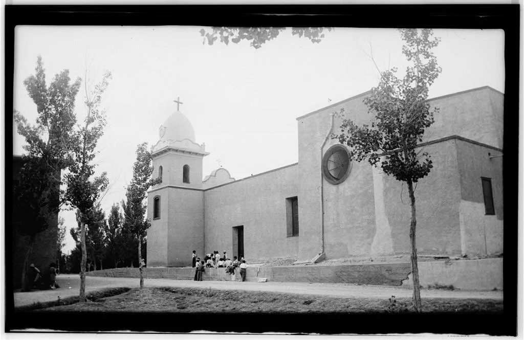
The Ysleta Mission is one of the longest continuously occupied religious buildings in the United States and serves as the spiritual center of the only Native American pueblo in Texas. The community of Ysleta del Sur traces its origins to the Pueblo Revolt of 1680, a significant uprising by the Pueblo tribes of New Mexico against Spanish religious, political, and economic oppression. Following the revolt, many Pueblo people, particularly the Tigua, along with a number of Spaniards, fled south for refuge and established Ysleta del Sur Pueblo in present-day El Paso County.
By 1682, Tigua labor had constructed the first permanent Spanish mission in Ysleta using adobe. Named La Misión de Corpus Christi de San Antonio de la Ysleta del Sur in honor of the Tigua's patron saint, Saint Anthony, it was maintained by Franciscan missionaries to Christianize the Tigua people.
YSLETA MISSION (South Elevation)

The resilience of the Ysleta community is evident in the repeated reconstruction and repair of the Ysleta Mission after disasters over the centuries. The adobe structure was severely damaged by Rio Grande floods in 1740, 1829, and again in the 1850s, but each time the mission was rebuilt. A chemical fire in 1907 damaged its roof and destroyed its facade and bell tower, but the mission was reconstructed in 1908, and the current dome was added.
Throughout its history, the Ysleta Mission has served as a lasting symbol and anchor for the community of Ysleta. Today, it remains an active parish of the Diocese of El Paso, and the Tigua people continue to be closely associated with the church.
In this photograph, the view of the structure from the side reveals how the building has evolved over time, with additions made to adapt to its site. Power lines stretch across the image, reflecting the reality of modern life in contrast to the historic building. This blend of the old and new highlights the ongoing interaction between the past and present, capturing the evolving nature of the site while honoring its historical roots.
SOCORRO
SOCORRO MISSION (North Elevation)
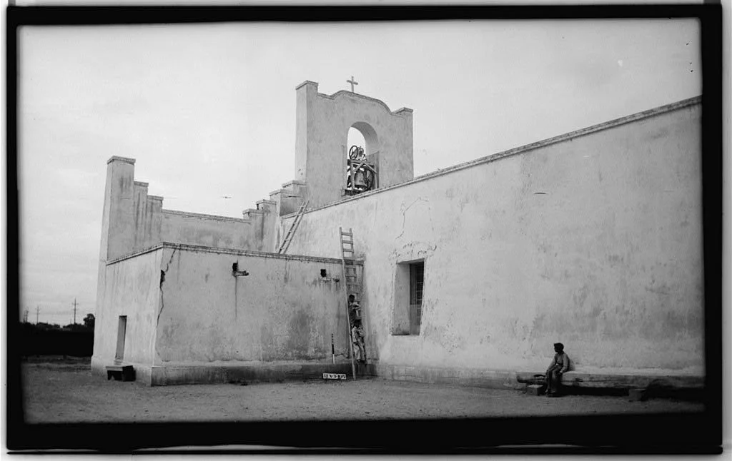
The Socorro Mission is considered the second oldest in El Paso County after the Ysleta Mission. Similar to the Ysleta Mission, the Socorro Mission was established by the Spanish and Pueblo people, including Piro, Tano, and Jemez Indians, who relocated to the El Paso del Norte area from New Mexico after the Pueblo Revolt of 1680. By 1691, the Piro had built a permanent adobe church less than a mile from the current mission. Though this original structure was destroyed by a flood in 1740, it was later rebuilt.
Eickenroht’s photograph of the Socorro Mission captures not only its architecture but also its functional aspects, particularly the ladders leading to the top of the building and the bell tower. This detail emphasizes the practical role of the bell tower in the mission’s daily operations and highlights the human scale of the structure, offering a sense of how people interacted with the building. By focusing on such elements, Eickenroht’s image brings to life the way these spaces were used, making it more than just a static record of the mission’s design.
SOCORRO MISSION (Southeast Elevation)

Ysleta, Socorro, and San Elizario were originally founded on the south side of the Rio Grande in present-day Ciudad Juárez, Mexico. They are located in Texas today due to a major flood in 1829 that shifted the river's course to the south, changing the international boundary. This flood also caused significant damage to all the adobe missions along the Mission Trail.
The present Socorro Mission was built in 1843 about half a mile northwest of its original location. This image emphasizes the iconic stepped cornice on the adobe facade, designed to represent a bird in flight or Pueblo pottery cloud designs. Eickenroht’s use of an unconventional angle and the inclusion of people in the foreground helps bring a sense of human scale to the structure, allowing the viewer to appreciate the mission's grand architectural features in relation to the everyday life of the community. This approach not only highlights the mission's symbolic elements but also underscores its role as a central and enduring landmark for the people it serves.
SAN ELIZARIO
SAN ELIZARIO PRESIDIO CHAPEL (West Elevation)

Initially constructed in 1789, the San Elizario presidio was built as a garrisoned fort to defend the area against Apache and Comanche raiders. A village grew rapidly around the presidio, and by 1850, San Elizario was the largest county seat in El Paso County. A small chapel was built in 1843 to accommodate the religious needs of the residents and was named after the patron saint of the military, San Elceario. The chapel was expanded into a larger church in 1877 and has been in use ever since. The 1877 expansion is what is seen today.
In Eickenroht's photograph of the San Elizario church, the formal framing of the building, with the vegetation in the foreground, creates a structured composition that draws attention to the architecture. This is balanced by the casual pose of a man seated on a low wall, taking notes. The relaxed posture contrasts with the rigid formality of the structure and adds a human element to the image, grounding the historical significance of the building in everyday life. It’s possible that this man could be Eickenroht himself.
JESÚS LUJÁN HOUSE (Southeast Elevation)

The house was built by Jesús Luján (c. 1813-1871) adjacent to the San Elizario Plaza, where the family lived and operated a dry-goods business. This was an example of a linear floor plan typical of early adobe architecture. It featured a hand-adzed door casing under a relieving arch of adobe brick with a roof supported by vigas. Exterior woodwork was made from cypress or cottonwood logs, which were likely shipped, according to Eickenroht. When the property was documented for HABS, it was described as practically in ruins and in “very bad” condition. By 1975, the structure was recorded as demolished.
Regardless, Eickenroht's photographs provide a permanent record, which was the original intention of HABS. Today, while we would consider this building endangered, it could also be easily repaired. While the building has lost its protective stucco coating and has suffered erosion at the ground level, these features could be restored. Adobe is incredibly durable, provided that water is kept at bay and skilled craftsmen are available to undertake the work. With proper restoration, the building could have been saved and preserved for future generations.
CASA GREGORIO GARCÍA (North Elevation)
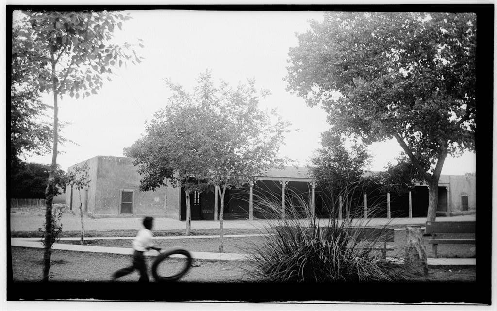
Casa Gregorio García was constructed around 1855 as a private residence by Texas Rangers Captain Gregorio Nacianceno García (1817-1896), a respected citizen of San Elizario. In addition to serving in the Texas Rangers’ Frontier Forces Division, García held positions as County Commissioner, Mayor, and County Judge of San Elizario. The structure is oriented toward the main plaza of San Elizario, reflecting its community significance.
In the 1870s, García donated the residence to be used as a schoolhouse, and it served in this capacity until 1922. Afterward, the building was converted into apartments, as it remained until 1965. Today, it serves as Los Portales Museum.
This photograph captures the building within its community context, showing a young boy rolling a tire, park benches, and sidewalks nearby. These elements emphasize the continued life and activity surrounding the historic structure. The image not only depicts the building but also reflects how it is integrated into daily life, preserving a visual record of the connection between the structure and its surrounding environment.
CASA RONQUILLO (Southwest Elevation)

Casa Ronquillo was named after José Ronquillo, a Mexican army commander who occupied the home in 1832. Ronquillo was a prominent citizen, serving as alcalde of San Elizario in 1830 and as the first presidio captain of San Elizario during its Mexican administration (1823-1847).
The house was originally constructed during the Mexican administration, around 1832 or later, after Rafael Corona sold the land to Ronquillo. However, it was first described in Ronquillo’s will in 1859. The house was part of a large compound that included twelve rooms, a courtyard, and a vineyard. Today, only five of those rooms remain.
Eickenroht sought to bring elements of modern day into his photographs, blending the past and present. In this image, a dog can be seen on the left, while the unpaved streets emphasize the rural nature of the area at the time. A glimpse of a vehicle bumper on the left, which may have been Eickenroht's car, is subtly left visible in the image, further bridging the historic with the contemporary. These details add a unique layer to the photograph, highlighting both the building's historical significance and its place in the modern world.